


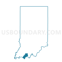
HAMMOND 02, Spencer County, Indiana
About
Outline

Summary
| Unique Area Identifier | 580633 |
| Name | HAMMOND 02 |
| County | Spencer County |
| State | Indiana |
| Area (square miles) | 23.87 |
| Land Area (square miles) | 23.63 |
| Water Area (square miles) | 0.23 |
| % of Land Area | 99.03 |
| % of Water Area | 0.97 |
| Latitude of the Internal Point | 38.00240410 |
| Longtitude of the Internal Point | -86.95934910 |
Maps


Graphs
Select a template below for downloading or customizing gragh for HAMMOND 02, Spencer County, Indiana


Neighbors
Neighoring Voting District (by Name) Neighboring Voting District on the Map
- CLAY 01, Spencer County, IN
- GRASS 01, Spencer County, IN
- HAMMOND 01, Spencer County, IN
- HUFF, Spencer County, IN
- JACKSON, Spencer County, IN
Top 10 Neighboring County Subdivision (by Population) Neighboring County Subdivision on the Map
- Clay township, Spencer County, IN (2,801)
- Hammond township, Spencer County, IN (1,727)
- Grass township, Spencer County, IN (1,241)
- Huff township, Spencer County, IN (1,156)
- Jackson township, Spencer County, IN (891)
Top 10 Neighboring Unified School District (by Population) Neighboring Unified School District on the Map
- North Spencer County School Corporation, IN (12,043)
- South Spencer County School Corporation, IN (8,909)